


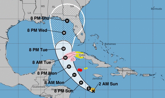
HAVANA, Cuba, Sep 25 (ACN) As it passes through the central Caribbean Sea, Tropical Storm Ian gained slightly in organization and intensity tonight, and now has maximum sustained winds of 85 kilometers per hour, with higher gusts, and a central pressure of 1,002 hectoPascal.
Its movement remains on a westerly course, decreasing the speed of translation to 20 kilometers per hour, says the Institute of Meteorology of Cuba in its Tropical Cyclone Warning No. 8, issued at 12:01, local time.
According to the report, at midnight Ian's central region was estimated at 14.7 degrees North latitude and 77.9 degrees West longitude, a position that places it in the waters of the central Caribbean Sea, some 630 kilometers south-southeast of Caiman Grande and 855 kilometers southeast of Cayo Largo del Sur.
In the next 12 to 24 hours the tropical storm will begin to tilt its path between west-northwest and northwest, with similar speed of translation, rapidly gaining in organization and intensity, with the possibility of reaching hurricane status this Sunday.
Due to the potential danger it represents for western Cuba, the Forecast Center of the Institute of Meteorology is keeping a close watch on the evolution of this tropical cyclonic organism, the warning states.
It adds that given its position and the forecast trajectory, tropical storm Ian could provoke strong winds, heavy and intense rains and coastal flooding in low-lying areas of the southern coast starting on Monday, September 26, in that part of the Cuban territory.
The next tropical cyclone warning for this system will be issued at 6:00 a.m. this Sunday morning.
Tropical Storm Ian intensifies slightly
Nos reservamos el derecho de no publicar los comentario que incumplan con las normas de este sitio