


HAVANA. Cuba, September 29 (ACN) Tropical Storm Imelda is strengthening on its path to becoming a hurricane, and in the coming hours it will continue to bring rain and strong winds to Cuba, mainly in the eastern and central regions, the Institute of Meteorology reported.
TROPICAL CYCLONE WARNING No. 6 TROPICAL STORM IMELDA...
Imelda strengthens over the Bahamas...
During the early morning of today, Tropical Storm Imelda became more organized and intensified, with its maximum sustained winds increasing to 75 kilometers per hour and its pressure decreasing to 996 hectopascals.
This system is currently producing areas of showers, rain, and thunderstorms, associated with its rainbands, over the central and eastern regions of Cuba, particularly in Santiago de Cuba and Guantanamo provinces.
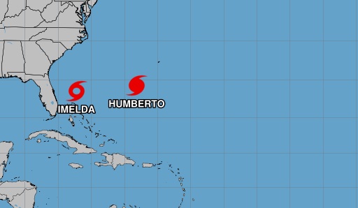
The center of Imelda was estimated at 6:00 a.m. at 25.6 degrees north latitude and 77.1 degrees west longitude, placing it near the Bahamas, about 70 kilometers north of Nassau and 130 kilometers south-southeast of Grand Bahama Island.
It is currently moving in a northerly direction at 13 kilometers per hour. During the next 12 to 24 hours, this system will continue on a similar path and speed as it continues to strengthen and intensify, becoming a hurricane in the coming days.
Regardless of its further development and future track, this system will continue to generate instability over our area, which, combined with high relative humidity, local factors, topography, and daytime heating, will favor the occurrence of showers, rain, and thunderstorms in the central and eastern regions of the country.
These rains may become heavy in some areas, particularly in mountainous regions.
The next tropical cyclone warning on this system will be issued at 6:00 p.m. this Monday.
Storm Imelda strengthens over the Bahamas
Nos reservamos el derecho de no publicar los comentario que incumplan con las normas de este sitio